Archive for April, 2011

2

Day 16 – No Longer Resting – Up and Over Emory Pass

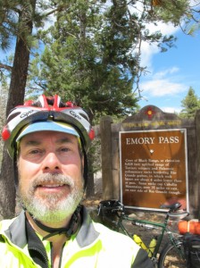
Self-protrait at Emory Pass

A self-portrait at Emory Pass.

8 April 2011. I got a fairly early start out of Silver City this morning: 7:30 am. I lingered long enough to get some breakfast at the hotel (opened at 7) and let the air warm a bit (from the low-40s). Initially, my left knee was pretty sore, but after pedaling a little while it felt much better.

My route took me east on Route 180 to Central, then on Route 152 through Hanover and up over Emory Pass to Kingston, New Mexico. Central used to be called Santa Clara, but the town became an open-pit copper mine, and residents were relocated. Indeed, the massive Santa Rita Copper Mine, easily viewable from 152, was my first stop this morning.

Read the rest of this entry »
2

Day 15 – Still Resting in Silver City – and a Visit to City of Rocks

City of Rocks

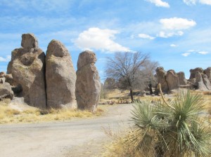
An afternoon outing to City of Rocks State Park, between Silver City and Deming. Click on any image to enlarge.

7 April 2011. Another day of generally taking it easy. After the continental breakfast at the hotel, I changed my room at the Palace Hotel to the less expensive single ($51) room I had originally wanted. That meant a bit of packing and organizing.

Then I took my bike to Gila Hike & Bike for a “fitting.” The saddle (seat) height was just right, but it’s about an inch to an inch-and-a-half further forward than it really should be—according to measurements that the co-owner, Jay, took using a plumb line. He was able to move the saddle back slightly, but less than a quarter-inch. A different saddle might allow it to set back further, but I don’t really want to break in a new saddle on a trip. I guess the frame should really be slightly longer for my body. Jay also adjusted the clips on my pedals so my shoes won’t slip out and secured the magnetic pick-up for the bike computer so that it should work better now.

Read the rest of this entry »
3

Day 14 – Resting in Silver City

Downtown Silver City

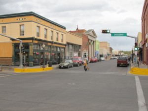
That's the Palace Hotel on the left--corner of Bullard and Broadway--where I'm staying. Click on any image to enlarge.

6 April 2011 (posted the following morning). If I were looking for excuses as to why I’m not bicycling today (or tomorrow), I could point to the “Red Flag Warnings” for the area. Prior to this trip I hadn’t come across that term—a high wind advisory—but I’ve seen it several times now. Steady winds of 30 mph with gusts in the upper 40s were forecast for today and tomorrow. I suspect that Emory Pass, which I’ll cross, is even windier.

Read the rest of this entry »

6

Day 13 – New Mexico, the Land of Enchantment

Route 78.

New Mexico truly is the Land of Enchantment. Here I'm coming out of the mountains on Route 78 into the Mule Creek Valley. Click on any image to enlarge.

5 April 2011 (posted the following morning). The biggest problem at the hotel I’m staying in is that my room is on the second floor. Coming upstairs to my room just now, after posting yesterday’s blog down in the front lobby, my legs are protesting loudly! I’m spent!

Though today’s ride was probably easier than yesterday’s (at least relative to elevation gain), I had worn myself out yesterday, so today’s ride was hard. I was also bucking a headwind most of the day—though, mercifully, it turned around toward the end of the day and helped push me up the gradual, 1,600-foot climb toward Silver City, where I am now. There was also a section of road today—Route 78 when I came into New Mexico (absolutely gorgeous)—where there are many steep dips and rises. On the elevation profile I have of the Southern Tier route, those level out, and the ride appears pretty-much flat, but on most of those uphills I had to shift into my lowest gear and really crank at 4 mph. Exhausting!

Read the rest of this entry »

10

Day 12 – Climbing into the Mountains Toward New Mexico

Climbing toward New Mexico

The notch in the far distance is the pass--preceded by lots of hairpin switchbacks. Click on any image to see a larger version.

4 April 2011 (posted the following evening). I’m at the Cole Creek Campground in Apache National Forest. Beautiful spot. As soon as I got over the pass from the west, ponderosa pine appeared; it’s great to see a tree again!. So it’s more than dust, gravel, and cactus at this campground, which is just over 6,000 feet in elevation.

Quite a day of climbing it was! I started around 7:20 at my WarmShowers host family in Safford. Over breakfast, I chatted with Mons Larson’s father—that’s the house where I’m actually staying. Real character. He must be at least 80, but is president of the Electric Co-op with 10,000 customers and seven or eight power plants—some coal, some natural gas; he also delivers excess milk to poor people and a soup kitchen. Also, a great sense of humor.

Read the rest of this entry »

9

Day 11 – Lots of Miles, Aided by a Strong Tailwind

From Route 70

Looking out from Route 70 in the San Carlos Apache Reservation, along my route today. Click on any image to enlarge.

3 April 2011. A few people have suggested that it doesn’t really matter whether you biking east or west; you’ll find headwinds either way. Well, so far on this trip, I’ve made the right choice by a long shot! Go tailwinds!

Today, I had a 20-30 mph wind coming out of the south, west, or southwest most of the day—stronger as I got further east. Once or twice when I had to pedal the other way (going into a grocery store, for example), it became ever so apparent that it would have been A LOT harder pedaling west today!

Read the rest of this entry »

3

Day Ten – Gaining Elevation (Carefully)

Leaving Superior

From Superior, Route 60 rises steeply for 2,400 feet. The shoulder here is pretty good. That didn't last! Click to enlarge any of the photos.

2 April 2011. In terms of miles, this was an easy day—only 24. But in terms of effort, concentration, and adrenaline, it was a challenging day. I had been warned about the Queen Creek Tunnel and this section of Route 60 by lots of people—and the warnings were well-founded.

Leaving Superior, Highway 60 climbs steeply right away. About two miles out of town, you pass through the infamous tunnel—peddling uphill with cars, trucks, and (loud) motorcycles racing by you at 65 mph. There are two lanes eastbound here, but virtually no shoulder. Some people suggest trying to hitch a ride through the tunnel in a pick-up truck; someone else was trying to navigate a route around the tunnel. But I psyched myself up and went for it.

Read the rest of this entry »

3

Day Nine – In Which I Make My Escape From the City

A canal path

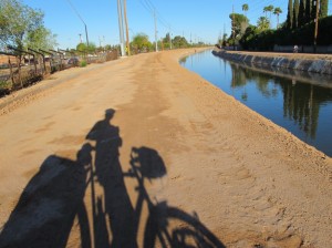
Long shadows in the early morning light on this unpaved canal trail; I'm facing west here. Click on image to enlarge.

1 April 2011 (posted a day later). I left the Dalrymple’s place at Chimney Rock fairly early—to try to beat the heat. The forecast for Phoenix was 99°F (and I heard tonight that the city tied a record of 100°). I got off by 7:15, after a packing and eating a bowl of cereal.

The trick was getting down to where I would pick up the Adventure Cycling route. The night before I had checked Google Maps and figured out what seemed like a good route. I started out just fine—riding downhill, then getting on one of those canal paths. At one point, though, I seemed to get off the route I had scouted, so I just tried to head east and south. Even without a compass, that’s pretty easy in a place like Arizona, where most streets are either north-south or east-west. In the morning, either you’re squinting into the sun, or it’s hitting the side of your face, sneaking past the edges of your sunglasses.

Read the rest of this entry »

2

Day Eight – Through the City, Hidden From View

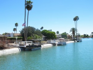
Dockside estates

I thought I was in the desert, not Florida! Everywhere I turned there was water in the Phoenix area. This was in Sun City, shortly after heading out. Click on image to enlarge.

31 March 2011 (posted a day later, from Superior, AZ). I left my WarmShowers hosts late morning, after catching up on blogs and making some lodging arrangements. It was nice to relax a bit. Larry had provided me with detailed instructions for getting on my way.

Whenever I’m in an arid area, I love to look at how adaptation to the climate is handled. The dockside homes above are a particularly bad example of climate-responsive design. But I did see lots of features that made sense, such as low-water landscaping (xeriscaping). The multicolor stone mulches add a bit of color!

Read the rest of this entry »