27 March 2011 (posted on 3/28 from a Starbucks in Blythe, CA). I started the day in El Centro and pedaled all the way to Palo Verde, which is about 25 miles south of Blythe, California, and just across the Colorado River from Arizona.
El Centro seemed to go on forever—seeming far larger and spread out than its 38,000 population might suggest. I didn’t see the town center; I skirted it as I was heading for a route that Brian had suggested—much better bicycling. And, indeed, the old Route 111 was smooth with wide shoulders and virtually no traffic—cars and trucks choosing the new Route 111 that parallels it the whole way up to Route 78—about 15 or 16 miles. That would be the best pedaling all day by a long shot—at least relative to the safety and quality of the road surface.
Route 78, which I pedaled on most of the day, and will take almost to Blythe tomorrow, started out fine, relative to the shoulder. Not a really wide shoulder, but wide enough. It was pretty bumpy, though. We have frost heaves in Vermont. Here, they have heat heaves I guess. About every 20 feet a jarring bounce.
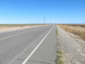
Nice wide shoulder on Old Route 111, which Brian suggested I take, avoiding one section of Route 78.
Along Old Route 111 and then 78, you pass thousands of acres of irrigated farmland, though some are fallow. I gather that farmers have sold their water rights to Los Angeles and other far-away places. Wheat, cotton, what looked like Swiss chard—and lots of hay and alfalfa (though I gather that the market dropped out of the hay business a few years ago; the hundreds of stacks of what looked like very old bales of hay support this contention. At one point I had to try to hold my breath as a farmer was applying pesticides on the upwind side!
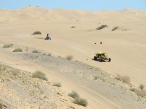
Pedaling along 78, there’s an odd whitish band you see at the base of the distant mountains. I think this is the famous sand dunes that Glamis is known for. Part of it is in the North Algodones Dunes Wilderness Area. The rest is a dune buggy haven. As I approached Glamis, there was a steady stream of huge pick-up trucks and lumbering RVs towing all sorts of dune buggies, ATVs, and motorcycles. Fortunately (at that point) most were heading west.
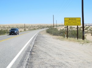
The Imperial Sand Dunes Recreation Area is a remarkable natural feature–though the usage isn’t very natural!
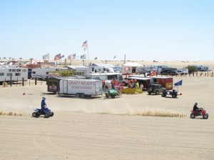
The dune buggies come with a whole culture. People “camp” (in their RVs) in the desert and bomb around with abandon, kicking up clouds of sand and dust. I stopped at the ranger station to get some water (he filled my water bottle reluctantly; there was no drinking fountain). There are little “villages” with stores in the campground area, repair services, probably even bars. Kind of makes you gag! I didn’t venture too close.
I stopped at the Glamis store thinking that it was also a restaurant. No such luck. After much searching, I finally settled on a pint of chocolate milk and a white-bread ham & cheese sandwich with those packets of mustard and mayonnaise. It cost $9, and the proprietor couldn’t have been more grouchy. I guess I’m lucky, though; the store closes down for the summer in May—when it just too hot around here to recreate—and its the only place between Brawley and Blythe (a distance of about 75 miles). My cashews from the Brattleboro Food Co-op provided the bulk of my lunch.
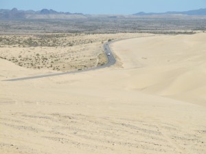
On a windy day, bicyclists can’t cross the dunes, due to blowing sand. In one place, I had to squint with my eyes almost closed as I felt the sand hitting my face.
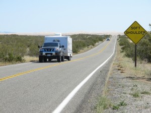
I had come 47 miles today by the time I got to the Glamis store, and I had another 37 or so to Palo Verde, where I had arranged to stay with a WarmShowers host. For a while after leaving the store I wasn’t sure I was going to make it. The road rises gradually as it approaches the striking Chocolate Mountains, and I was only making 8 or 9 miles an hour some of that time—my right knee aching. Worse, the paved shoulder disappeared, leaving only about a foot between the white line and the drop-off to the gravel shoulder.
And meanwhile, the stream of dune-buggy-towing trucks and RVs increased significantly, interspersed with some cars and tractor-trailer trucks. Route 78 at this point was quite hilly and curvy; it made for some scary pedaling! Several RVs and one tractor trailer truck passed me a little too close for comfort. Remarkably, the speed limit here, which few seem to follow, is 65 mph.
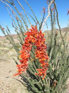
I didn’t see many flowers, but some of the Ocatillo is coming into bloom. The tiny leaves are shed in the summer.
But I finally made it to the designated rendezvous point just outside Palo Verde, where my WarmShowers host Nancy was waiting for me. She lives a little ways from 78 and drives out to guide visitors back to her place.
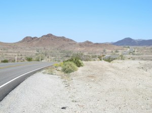
Despite the need to concentrate on the traffic, the scenery was beautiful; those are the Chocolate Mountains.
Nancy is very generous to make her home available. She’s not a bicyclist herself, but she saw all these bikers going by all the time and realized that they needed a place to crash. She found out about WarmShowers and now hosts a couple bikers each week. She even has a bicycle stand in her yard—so that bikers can work on their bikes!
I got here around 5:00, and after putting stuff in her house we drove over to the Arizona side of the Colorado River to a place she goes to hang out most days around that time. The river was full and rushing, but there’s a cove with fairly sandy beaches. Though the water was pretty cold, I went in for a swim, then soaked up the warmth while my bathing suit dried. Returning back to her place, we had dinner she fixed, I did the dishes, and now we’re both typing on our respective computers outside next to a fire.
It sounds idyllic, but I’m feeling somewhat down on this area. It’s not a bastion of liberal thinking—Nancy teaches Yoga in Blythe and she gets calls asking if it’s a cult and whether there’s chanting. I don’t think I would do well around here—especially in the summer with the temperature often above 105.
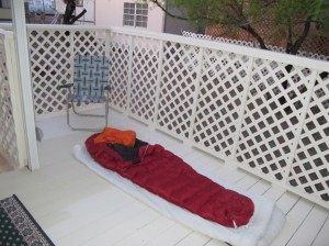
After pedaling about 84 miles today, I think I’ll take it easier tomorrow. Perhaps I’ll get to Quartzite, Arizona. It’s about 50 miles from here, though I should go study the maps before I roll out my new sleeping bag—I think on the back deck.
Wowzeezowzee! Nice legs! What’s the name of your bike? “She” must have a name, yes? Hugs and safe cruising, Connie
Keep on keepin’ on! You’re doing great. Look for Darlene’s on the left in Quartzite for great pie. You’ve earned it!
Great to be following along here, Alex. Wave hi/goodbye to California for me.
Howdy I am so thrilled I found your blog page, I
really found you by accident, while I was browsing on Digg for something else, Regardless I am here now and would just like to say thank you for
a marvelous post and a all round enjoyable blog (I also
love the theme/design), I don’t have time to look over it all at the moment but I have bookmarked it
aand also added your RSS feeds, so when I have time I will be back to read more, Please do
keep up the excellent work.